Learning About Regenerative Agriculture

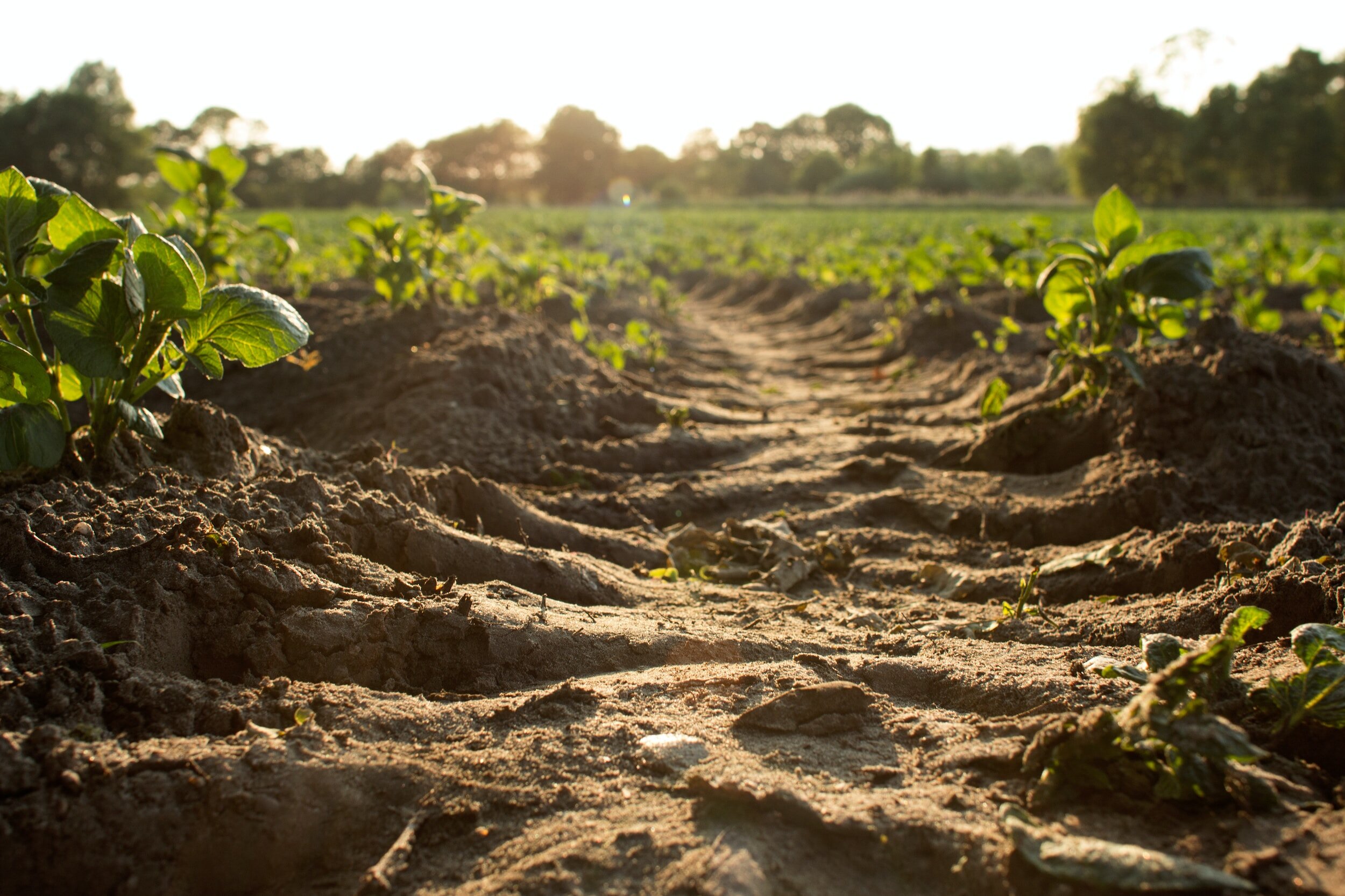
This image is a good representation of what regenerative agriculture is not. What do you think happens to the soil when it rains? Where does the water go? Is the soil healthy? Answers: The soil erodes as the water runs off and is not absorbed because this soil is unhealthy due to the agricultural practices occurring.

Learning about regenerative agriculture has been a process that not only feels timely, but critical. I cannot think of other times, if any, where I felt I was on the wave of opportunity and change, where the “landscape” of a movement is gaining traction so quickly. I must admit that I enjoy this wave. The passion of learners and teachers who preach the gospel of Regenerative Ag. do not preach the word for monetary value (not many anyhow), they preach for the Hopeful Future. These are the people who have taken a step back to look at our food system and pinpoint a systemic issue, soil health. Although they are not the discoverers of such practices, they are adding a modern accent to the practice. 


So what is Regenerative Agriculture? That is a burning question that many governmental bodies are currently attempting to define. To me, it is An agricultural practice that continually improves the health of the ecosystem, minimizing or, ideally, excluding harmful practices. A simple definition that allows for creativity in practice, allowing for tailored styles of agricultural practices because as we know, each plot of land is different from the last. 


Why is this so exciting? 


Our modern agricultural practices, sometimes referred to as “Industrialized Agriculture” or “Conventional Agriculture”, have a small…addiction, if you will. Actually, it is not so small, it is the application of hundreds of millions of tons of chemical fertilizers, annually. It is one of the largest challenges facing our planet today. 


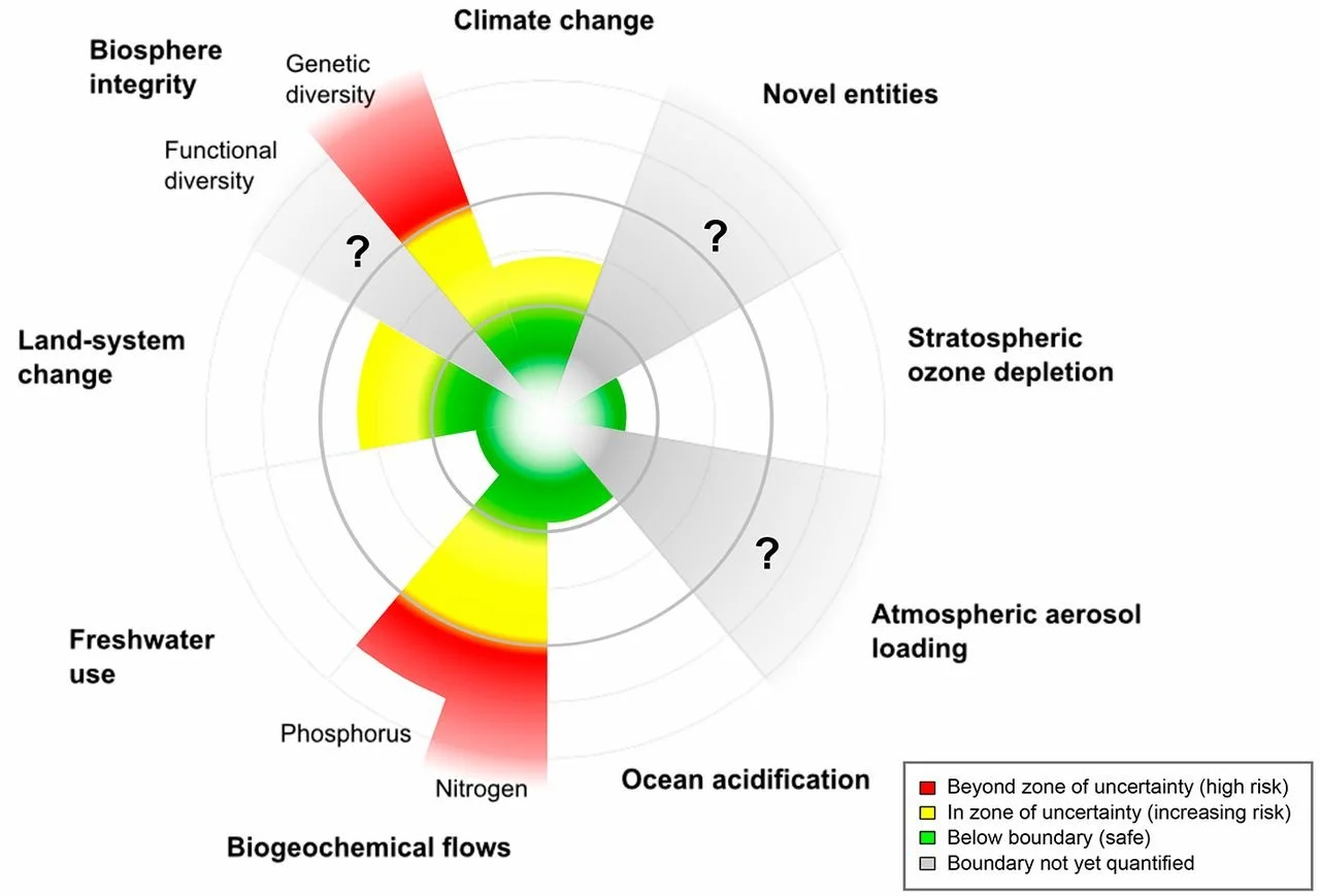
Taken from Science.org. The image represents the nine planetary boundaries that we are impacting, and rely on. As you can see, Nitrogen and Phosphorous are through the metaphorical roof. “The major anthropogenic perturbation of both the N and P cycles arises from fertilizer application”. Phosphorus is another issue that I’ve touched on.


This practice has not been going on long, the super-brief history of it is that the modern chemical fertalizer used to increase soil nitrogen, called ammonia (a primary nutrient of plants) was invented in the early 20th century by German scientist Frtiz Haber. The new fertilizer grew traction slowly until after the second world war, when is became widely adopted. Crop yields soared and food was plentiful. What wasn’t recognized was that the fertilizer was detrimental to soil health and after a handful of years, the soil health declined. How was the problem remedied? Add more fertilizer! This produced a positive feedback loop where more and more fertilizer was needed each year to produce the same quantity (This is important, remember this) of crops. 


This is where regenerative Ag. comes in, it allows farmers to jump off the synthetic Nitrogen treadmill and begin holistic land practices that do not degrade the very land they depend on for a livelihood and nutrition. 


Food produced on regenerative Ag. plots vs conventional plots can not only match the quantity of crops produced without additional fertilizers, but has a dramatic increase in quality of crops produced. And when the expensive inputs of fertilizer costs are removed, that means there is more room for profits at the end of the year. 


You may be asking yourself, why isn’t the practice of regenerative agriculture being practiced all over then? The long and short, policy. Policy is a huge driver of agricultural practices as well as insurance and crop subsidies. 


Coming to this field with an ecological background is exciting, to learn of the intricacies of agricultural relationships is akin to learning of natural ecological relationships. There’s even a name for it, Agroecology! I mention this because looking at agriculture from an ecological lens makes sense and when asking a few questions about it, seems to make more sense. 

Does crop quality suffer when soil quality is degraded? 

Are crops intertwined in the ecological landscape or are they separate? 

Do healthy soils produce healthy crops? 

Do resilient soils produce resilient crops? 


Answer them how you please, but I pose them because, from an ecological view and quite literally, crops are a product of the soil. Soil health = Crop Health. That may be oversimplistic due to various factors, but overall is agreeable. Expanding on the thought that crops are a product of soil, animals are a product of crops/forage and we are…a product of a combination of those two…so…we are ultimately…a product of soil? Yes. Soil health is indicative of human health and it doesn’t take a lot of digging to discover that North America is having some troubles. Remember, we are currently producing for quantity of calories over quality of calories. 


Regenerative Ag. is exciting because it is simultaneously tackling several issues that humanity is facing (disease due to lack of nutrition, food shortages, biogeochemical imbalances, soil loss, ecosystem degradation, pollinator loss, Green House Gas emissions, and more), by changing the way we grow food, we cannot only improve the quality of life on Earth, but we can sustain it. 


Care to learn more? Read some David R. Montgomery a professor at the University of Washington, specifically his books: Dirt, Growing a Revolution, and What Your Food Ate


Another book that gets more into the quantity vs quality of agriculture is The Dorito Effect by Mark Schatzker. 


I have no affiliation with the provided links or Thrift Books. If you are going to buy a book, please support your local bookstore or library :)


To Plant a Forest

Somewhere along the GDT.


The thought crossed my mind before dawn. I trampled my way through thickets of bushes led by my headlamp while Poncho, my dog, scoured through the underbrush with joy. Can forests be planted? I suppose this is more of a philosophical question than one of science, although, with some set criteria, it certainly could be.


The answer would depend on what one’s definition of a forest is. Is it a plot of land dominated by trees? How many acres must the land be in order to be considered a forest? Does there need to be diversity among the habitants? After the initial thought of “What is a forest?”, the definition becomes more complex.


I stand on the side of; No, a forest cannot be planted.


To say a forest can be planted is to limit its inherent ability to be wild. We can plant one aspect of the forest, the vertical structure, trees, but we cannot apply the details that make forests so special. We cannot force the birds to return, the mammals to roam, nor the insects to crawl. We can, however, invite them.


Aldo Leopold says in his famous essay The Land Ethic that there is an “A-B Cleavage” or a division between perspectives of what a forest is. Group A is happy to grow a forest like cabbages, viewing its inherent value in the volume of cellulose, while group B sees forests as fundamentally different than agronomy because it employs natural species and manages a natural environment. Group B considers other functions of a forest such as: wildlife, recreation, watersheds, and wilderness areas. Aldo finishes the paragraph by writing “Group B feels the stirrings of an ecological consciousness.”.


Humans can facilitate the return of species by creating a viable habitat, as said in the film Field of Dreams “If you build it, he will come”. It is commonly misquoted as “If you build it, they will come”, which is the example I prefer to use here. Planting native flora allows a forest to begin, but it is not ultimately established until it supports life and provides habitat for local citizens of the wild.


Sebastião Salgado and his wife Lélia Deluiz Wanick Salgado, have been establishing a forest that now provides habitat to wildlife. Sebastião’s family land had been decimated, hardly a tree in sight, and rather than mope about the situation, he and his wife chose to change it. Their goal was to reforest the land, and they have done just that. By planting over 4 million native saplings, they have created an ecosystem that now thrives with life.


“You need forest with native trees, and you need to gather the seeds in the same region you plant them or the serpents, and the termites won’t come. And if you plant forests that don’t belong, the animal population won’t grow, and the forest will be silent.” - Sebastião Salgado


Following their philosophy of native planting, they have successfully created habitat for several species not previously documented on their land. There are now over 170 species of birds, 33 species of mammals, 293 plant species, and 15 species of amphibians.


A satellite time lapse of the land reforested by Sebastião Salgado and Lélia Deluiz Wanick Salgado. credit: Insituto Terra

Beau Miles, a contemporary YouTuber, known for crazy, off-the-rails local challenges chose to plant 1,440 trees in 24 hours and for those of you who are quick at math, know that this is a tree a minute, for 24 hours. The feat itself is incredible and the video is entertaining as always (Video is here), but I challenge the notion that he planted a forest.


Beau will have to wait for his forest to exist, he has laid the foundations, which is all we can do as humans. The land he planted the trees on would not be classified as a forest, it is missing…. something, which is why I say forests cannot be planted. There is a touch of life that is exclusive from human intervention which completes a forest. The touch of wilderness, of life completely independent from our own that completes a forest ecosystem. Without it, we have just planted crops.


Beau will have to wait as there is nothing more he can do to hurry the process of transforming his tree plantation into a forest, the process is reliant on nature now. He will undoubtedly appreciate watching his plantation transform into a forest, the gradual noticing of new species, and the splendor of watching the change he set in motion.


Planting a forest is a theoretical statement, it is up to each individual to determine if the task can be done. Unlike the structures we create, a forest is not complete once the last nail is hammered in, nor the final tile laid. Time is baked into the creation of a forest, free from the influence of humans and our hurried ways. Forests contain immense wonder and beauty because they are an expression of the processes of the earth, a dynamic mystery subtly changing day by day.

Leaf it to Others


As fall deepens, the changing trees stand testament to the season's beauty. These trees, different in species from those I'm familiar with, share a common characteristic – they are deciduous. The sight of their bare branches against the grey skies is a reminder that, as in life, change is constant. This leads us to a curious fall phenomenon – the shedding of leaves and what becomes of them.


            This shedding of leaves, a spectacle of nature, brings us to a modern suburban ritual: the emergence of leaf blowers. As quickly as lawnmowers become silent, leaf blowers take the stage, marking a seamless yet significant change in our seasonal duties. What I have noticed between the leaf blowers and the lawn mowers, is that the lawn mowers collect their clippings or leave them strewn about the lawn, whereas the leaf blowers blow their leafy litter into the streets. 


“Into the streets?! “ quipped The Youth.


“Yes, into the streets” said The Man


“But won’t the wind just blow it back aga….”


“Shhhh” The Man raised a finger to his lips “the cost of “perfection” is a constant struggle.”


I shouldn’t say all leaf blowers are culprits of this trend, there is the occasional leaf sucker collecting the leaves into a backpack-like container. Pretty neat. Leaf blowers working as a team, particularly for an organization like the University, blow all the leaves towards a truck where it is collected for removal. If you’re still reading this, leaf-blowing may strike a chord in your heart or you may be attempting to learn about the leaf-blowing business to save for your first car, either way, thank you. You may also be wondering, why is this guy going on about leaf blowers?


            There is a core issue here, the leaf-blowing people who blow their leaves about willy-nilly into the streets. Firstly, and this is my observation, when blowing leaves off your property and into the street, they are bound to end up on someone else’s property and when hundreds of people practice this “removal” it really solves no issues for anyone. It is equivalent to collecting streamside trash, driving up river to dump it, and having to collect it again the following day. There is a proper disposal technique. The larger issue at hand is The Tragedy of the Commons.

One of the largest piles of personal leaf collection observed this fall


            The tragedy of the commons is an ancient issue (which I learned researching for this post) and has struck civilizations back to ancient Greece. Aristotle is quoted saying “That which is common to the greatest number gets the least amount of care. Men pay most attention to what is their own: they care less for what is common”.


When I learned of the concept of the tragedy of the commons it was in reference to grazing in the American West, cattle were free to roam about and graze as they wished, until the day when those cattle had grazed all the grass from public land and the grazing collapsed. Ultimately, it was no rancher’s fault, but poor management. Today there are grazing fees and stocking rates (measured in animal units /acre or AMUs) to help manage the publicly held land. A more modern and relatable saying would be “not my property, not my problem” and when you take a minute to dissect this statement, the results are not great. For example purposes, we’ll apply it to leaf blowing here in London, Ontario.


            Not my property, not my problem is inherently selfish and abandons the concept of neighborly love and community. All of those leaves that once littered the yard are now someone else’s problem (personally, I’d like to see the leaves naturally decompose, that’s for another day). They may blow into your neighbors’ yards, the schools, the streets, and even back into your own!


Before you get stirred up about these dastardly leaf-blowing low-life’s let’s take a step back and consider this on a societal level. Does society permit this behavior? Absolutely. Our society, I’ll speak of North America, encourages this behavior and permits it on a much larger scale than leaf-blowing. You may once again be thinking why is this guy going on about leaf blowing?


“It’s no longer about the payment, it’s about the principle” my roommate would say and it’s a good line when not used to intimidate folks. It’s not about leaf blowing it is about the principle of leaf blowing. This is a massively widespread issue and it is not about leaves. This issue extends to manufacturing, industry, agriculture, and even your local water treatment plant.


All of these sectors of our world are permitted to litter and, stay with me a second, this isn’t an eco-rant, they do it knowingly. There is a government-assigned threshold of water quality and the threshold is not zero. Therefore, as long as the water, or air, leaves the facility below the threshold, it is legal…but where does it go? Into OUR *gestures around* lakes, rivers, and air. Where it accumulates for generations to come (Refer to Let’s Go Swimming).


It’s not just the leaf-blowing neighbors who our crashing our collective party, it is everyone and everywhere. It is normal for everyone to exercise their, and participate in, the tragedy of the commons, whatever that “common” resource may be. It is completely normal, but that doesn’t make it okay.


Picking up your lawn leaves may be a pain, but it is your responsibility. Don’t place the burden on your neighbors and community. There are people to pay who will manage your waste for you, it is a booming business because everyone creates waste. Rather than follow the “not my property, not my problem” mantra, practice the “do your part” mantra, build your community, and create a culture where everyone can be responsible.


Give Me Gravity

Give me Gravity. 


Give me the experience of gravity and all that comes with it. 


Give me the hidden trailhead that is shrouded with overgrown Dogwood. 


Provide the strain of steep grades, switchbacks, and passes. 


A view that is earned. 


Simultaneously stimulating my psyche and aching my body. 


Let me feel the enjoyment of a simple meal atop a peak.


 Sandwich, sweets, water.


Provide me with navigational landmarks seen from afar. 


Shelter me from the winds in craggy nooks and under ancient boughs. 


Let the experience of gravity clutch me wholly as I descend.


Wheels spinning, Skis floating, Shoes clapping. 


Let me feel limitless through descent.


Let me pass turbid rivers who fall alongside me.


Let me witness birds of prey riding mountain updrafts.


Let me feel small, challenge me, and never budge.


Give me Gravity, give me Nirvana. 


No More 7's

I’m telling you to drop your 7’s. Surely you have some, everyone does. I do. They’re too easy to come by. Chosen for their convenience, harmless nature, and agreeability the 7 will get you nowhere.

On a 1 to 10 scale the 7 lurks near the top and far from the bottom, about 7/10ths of the way to being the best. It will not displease the asker, nor disappoint the reviewee for it is The 7.

“How was the sandwich?” Susan asked, her heart pouring with curiosity

“Mmmm 7 out of 10” Herbert answers

What does Susan gain from this review? Was it good? Somewhat. Was it a poor choice? Perhaps. Should Susan order it next time she dines at Sandwich Land? Who knows!

Drop your 7 review. Immediately. It does no one anygood and has your choice spinning in a whirlpool of mediocrity. Next time you review something on a 1 to 10 scale, do yourself a favor and lose the 7.

Did you know that 7 out of 10 Americans don’t know 7’s neighbors? (that may be false)

The point I’m trying to make is that 7’s neighbors, 6 and 8, are very kind to you and are much more telling of an experience. 8 basks near glory of the coveted 10, while 6 has squandered that glory and tip-toes failure. By choosing 7’s neighbors you can move on with your life, it provides a framework for decision making that is way more efficient than the 7.

Try it. Next time your asked for a rating on the 1 to 10 scale, don’t choose a 7, even if 7’s are hanging from your ears and screaming from the roofs….don’t do it! Choose a 6 and know that the choice should not be repeated, choose an 8 feeling satisfied with your choice and be open to choosing it again.

“How was the meal Susan? On a scale of 1 to 10?” Herbert slips out between bites

“Herbert, it’s a 6.” Susan says with stern disappointment. Herbert winces at the review, feeling sorry that his burger is a 9 of 10, he decides not to share a bite and provide Susan with a greater sense of Fomo.

Shortly after Herbert and Susan finish their meal, they leave the bistro, depositing a cash payment under the coffee cup including a tip. The waiter clears the plates and collects the payment, counting the money he finds himself with a $7 dollar tip.

Gapping Geese: An Exploration of Space and Time

The brake lights didn’t flash, nothing did. It was not until I noticed the distance between us closing quickly that I applied the brakes, it was too late.

I slammed into the back of her bike, tumbling from my clipped pedals, introducing my left knee, hip, and shoulder to the pavement. Why? Why did this happen on a designated bike path?! Why stop?

Geese.

The large avian life forms, named after our native land, waddled pleasantly from clipped park grass to, more, clipped park grass. Geese have struck fear into the hearts of many, hissing like 100 cobras, wings spread with malice as they chase you with their serpent necks extending from a potentially delicious roast. At this point, the human enters the state of mind known for its catchy primal ring “Fight or Flight”.

The gaggles of geese crossing the path, may be intimidating, but they are not crossing in continuity, in fact, one may view the event a bit like Frogger. An active gap, a distance per se, moves in the absence of geese, just as in the absence of letters there is . Yes, space. Here is where “Fight or Flight” instincts come to play, does one wait for all the geese to cross until one can ride by safely or does one locate the dynamic gap in the geese and shoot through it like the Millennium Falcon?

I’m 100% a Millennium Falcon goose gapper and my method is as follows.

If the geese are moving perpendicular to the rider and there is an appropriate sized gap for a bike, then why waste an opportunity to continue the ride uninterrupted? In fact, if I ride faster, the distance between the geese will appear more stationary than if I were to slow down because of our relative velocity.

If you don’t want to watch the video, I understand, but, basically, the faster you travel relative to another moving object, the greater your relative velocity.

Bike @ 30km/h //\\ Goose @ 1.3km/h //\\ 30km/h - 1.3km/h = 28.7km/h //\\

Therefore I would be moving at a relative speed of 28.7 km/h to the basically stationary geese.

You can guess the opposing strategies employed by my spouse and I. Discussing the goose scenario before riding with your partner is crucial to communicative and dermatological well-being.

Next time you ride into goose country with your riding partner be sure to ask,

Do you ride or step aside?

Section E: A Brief Writeup

Section E: Saskatchewan Crossing, AB > Jasper, AB. 183km


Over the next seven days, I was introduced to more vast landscapes. The Howse was just a taste. 


We slept at Michelle lake the first night with a couple other groups. The lake was some shade of glacier turquoise that I had never seen before, when reflecting the sky it beamed from another dimension. We crossed the highest point on the GDT the following day, it was a long climb up the alpine gravel. Apparently there was lots of fossil evidence on the pass, but our untrained eyes were unable to detect any. Our day took us to another lake, Pinto. The water had to have been transported from the tropics, not for warmth, but for coloration. We saw white beaches disappear into Cayman seas. Another night of lots of folks, this time all current or past GDT hikers. It was fun to talk trail with others who had shared the same experience with us, it was the first time since we had started the trail. 


We transitioned to the alpine environment via the Whitegoat Wilderness, a nook in the mountains where all animals are protected from any form of harassment. A large boulder just off the trail was once the canvas for indigenous folks, leaving behind strange and indecipherable ochre symbols. 


Hiking through large sweeps of valleys all linked by passes escorted us for the next several days. The scope of the land sent our senses of perception in whack, what looked near, was far, what looked short, was tall. Glaciers crumbled across the valley.

 After several days of alpine and bush bashing, we plopped into Maligne Lake resort. Society is bustling. There are tourists gawking around, nametags hung on necks, and lines. Long lines reached into walkways, blocked strollers and created anxiety in the hearts of Bush Walkers. Society did mean that we were close to resting though, nearly to Jasper. We slept at Evelyn Creek, 4km in to the 45km Skyline trail. Jackie, who had started the same day as us, was in jasper a day ahead and said that if we could make it, we could crash on the hotel room floor. What a sweet deal it was because we also had no reservations for the following night. 


At 3:30am we shut off our alarm. By 4:20 we had our headlights guiding our path as we walked. At 8am we had climbed the notorious "The Notch", which commonly chewed up and spat put day hikers. As seasoned thru hikers, with nothing but granola bars remaining as food, we boosted up the slope without stopping in 25 minutes. Cake. By 10am, we had covered 21km, or 13 miles. Almost halfway there, but with no more climbs in our future, we set the cruise control and made for Jasper. It was 4:30 pm when we arrived in town, just 12 hours after departure, we covered 47km (29 miles). Both of our biggest hiking days ever.

Section D: A Brief Writeup

Section D: Field, BC > Saskatchewan Crossing, AB 105km


Section D was the shortest section of our hike, a mere 105km over four days. It was the closest to home and we would really not be too far from a "local" road until day three of four. I would describe the section as the least maintained (so far), much was left to go "back to nature". A couple we met on trail, Lowell and Jenette, said that Parks Canada advised them not to go on either the main route nor the Kiwetinok Alternate as they are "wild and unmaintained". The calling for a GDT hiker. 


From Yoho we made it to the Blaeberry where we started on the David Thompson Trail, a historic route of the first person of European descent to cross Howse Pass. Howse Pass was not much of a pass at all, in fact, I wouldn't have known it was a Pass had it not been for the metal and wooden signs plopped in the center of the woods. 


Howse Pass opened up to the Howse Valley, home of the Howse River. Our first inkling of a "Northern" ecosystem; Braided Rivers, Lodgpole Pine and kilometers of floodplain. It was an open and expansive area where the nearest mountains were distant and all the while looming high. The floodplain was decorated with flowers of pink, gold, and red; studded with minute spruce; a media to capture the highway of animal tracks. This area was fully considered "unmaintained" by Parks and felt the part. Common Juniper and willows cut at our shins as we fell through the brush. Trees fallen this way and that over the trail pushed us around. Attempting to avoid riverside obstacles, we crossed streams of the Howse in order to walk on the gravel bars. Kilometer after kilometer we walked along the silty sweeping river, we felt miniature in the vast landscape. 

Section C: Mt. Sarrail, AB to Field, BC. 202 Km

This post may also be found on Thetrek.co

July 11: Mt. Sarrail > Palliser River. 26km


Freshly filled packs once again weigh on our shoulders and hips as we take off for Palliser River. While leaving Kananaskis we passed by several signs warning backcountry campers of the significant remaining snow and that summer was indeed “3 weeks late”. All of the high elevation sites were closed to camping, but that was okay for us, because we would be passing by and not staying. It did however stir concern, if the trail was in actuality too snowy to pass, then we would need a contingency plan. Our minds set to continue until we could not, or did not feel safe, we brushed off the signs as being suggestive and continued on. We had probably experienced worse. 


Halfway up the ascent we hit snow, section A all over again. It did slow our progress, but didn’t stop us. It was walking on familiar ground, the same we had been doing for the two weeks prior, by now we were masterfully dancing on the slush, pirouetting around fallen trees and vaulting others. We made it to Three Isles Lake, an alternate to the GDT main route, completely isolated amongst wicked peaks and glacial lakes. It wouldn’t be proper to leave such a place without a skinny dip and sun bath. 

A typical scene from snowy, uncleared paths. Yes, that is “the trail”


Three Isles Lakes was gorgeous. Surrounded by wicked peaks on all sides that stacked stratified layers of rock formed in a wavy prehistoric acid trip. 


Beatty Lake was not far away, marking the final ascent of the day. Another stunning lake as it was, we had no time for a swim. It was already 5pm and we had many kilometers left to go before we could call it a day. We wound our way down the mountain following a trail of loose cobbles primarily used by four-legged critters. The mountains around us as we entered Height of the Rockies Provincial Park looked like sharks teeth, row after row of acute angled peaks bit into the blue sky. 


We were nearly to our campsite, one kilometer to go when we approached our first river crossing. It was a concern before we saw it. The thick bush would not allow a glimpse of the rumbling torrent, walking parallel to a sound created by no small river. We may have hit our luck's end. The trail would not turn, would not allow us a sight of the river, we continued up stream. Finally, a view. What we had heard was a series of cascading falls, where we stood presented a gray silty wash. Lucky. It was slightly braided and we chose to hop braid to braid of the stream so as to not cross the river in its entirety. 


Less than one kilometer from camp and one more river, the Palliser River, then we can sleep. It was 9pm. Emerging from the bush to find a bigger river than before, we were screwed. Walking downstream, river to our left we looked for anywhere that might be crossable, no such luck. We were eventually cut off from our downstream search by a confluence with a smaller stream. Shit. We pulled out our map and GPS, checking we had come the right way. We did, but, we weren’t looking the right way. It was the smaller river that had cut off our downstream search that we needed to cross, a creek more than a river. Thank goodness, that would’ve been an awful 26km backtrack. Wading across and arriving in the meadow, we hastily set up camp, made dinner and went to sleep. It was 10:30.


July 12: Palliser River > Big Springs. 29km


Dare I say that summer is finally here, the warmth of the day was great. 


A 700 meter climb punctuated the beginning of our day, after that…flat. Yes indeed, it is rumored and confirmed by both map and GPS that the Spray Valley, the headwaters to the Spray River, is flat. Our climb up was hot, we had a late start to the day and felt the intense heat beating down as we climbed up the pass. The top was, as usual, snow bound. We gradually descended as we started through the headwaters of the Spray River, the valley warmed and snow disappeared, leaving a wetland in its absence. The 12 kilometers opened up a side of Banff National Park that I never knew existed, only imagining the tourist townsite as the main attraction. 


We walked in a long flat valley enclosed by stunning peaks. The shades of green varied all around us, from the grasses at our feet to the highest alpine in the transition to stone. 


The Spray River headwaters maneuvered in tightly coiled oxbows, so tight that one could fish both sides of the river from a single spot. We traveled along the valley, watching the river grow and develop as more streams joined into the collection of water bodies. 

Notable Features: Spray River headwaters, flat trail, grizzly country, wading, swimming


July 13: Big Springs > Porcupine. 29km


29km is just too long of a distance for a hike to be enjoyed for the entirety of the day. Same as yesterday, at 25km I was ready to be done. 


The parks bring out the people. We saw more people today than we had the previous two weeks combined. We pass by, catching whiffs of shampoo and laundry soaps, while they perhaps catch aromas of sweat, body odor and other bodily scents. Many people seem to like our shorts, maybe because they’re mostly all in pants and wishing for a crisp mountain breeze upon their upper thigh. Who knows. The parks also bring out trail crews, and they do a fine job of maintaining trails. With well taken care of trails we were able cruise along all day, not doubting our directions or bushwhack through thickets of foliage. In fact, the only time we were lost today was in a campsite, not a proud moment, but that was one confusing campsite map that did not clarify the river crossing. 


We crested Wonder Pass into Assiniboine Provincial Park, met with views from a mountain fantasy. Vibrant green larch forests coated the valley floor, prominent peaks dotted the skyline and a trail of perfect splendor brushed us along towards picturesque huts. No wonder it’s also a UNESCO World Heritage Site. We arrived at Assiniboine Lodge at the wrong time, also on the wrong day, for us to get beer. We took our time with lunch in front of the lodge, enjoying our lovely wraps and the view of Mt. Assiniboine. From behind us came an employee of the lodge and with all the kindness we could muster asked if there was any way she could get a couple beers for some dirty GDT hikers. The charm was on, after a nice chat and $20 we had two cans of cold beer. Oh yea, did that ever hit the spot. I’ve never been more willing to pay $20 for two cans of beer than at that moment, I doubt it will ever be surpassed. 

Mt. Assiniboine


Notable Features: cresting Wonder Pass, beer at lodge, dinner guests


July 14: Porcupine > Egypt Lake. 26km. 


Today we walked right up to Sunshine Ski Resort outside of Banff townsite. The trails became even more neat and manicured as we approached the lifts. The Ski resort isn’t the GDT main route, but a small detour, and worth it. The gravel hill above the lift stations dawned sandwich boards for the Banff Smokehouse. We were sold. How lucky could we be to have beer the day before and another today?! 


Although a very poor representation of a smokehouse, nothing was smoked on the menu, they did have a glorious, fully loaded, massive, heaping cheesy plate of nachos. Topped with Chili.


We ate more than we could handle. Our ciders went down smooth and while waiting to digest our bloated uncomfortable meal, a woman walked over with half a pitcher of sangria, explaining that she and her husband couldn’t finish it, offering the concoction to us. Yes please. It took us three hours to leave the resort, still uncomfortably full, we needed to continue. Two passes, 13 km, stood between us and our sleep. 


Notable Features: Sunshine Village, Nachos, Assiniboine from Citadel Pass, Pooping, Larch Alpine Meadows


July 15: Egypt Lake > Numa Creek. 25 km. 


Today was going to be special, we were crossing highway 93, a highway we had driven several times. We neared home and a rest day. Today was also the day that Parks Canada had refunded our reservation because Floe Lake Trail was closed. We would have to take an alternate route, bypassing the astonishing scenery. 


The two passes, Whistling and Ball, posed little challenge to us, they were miniature relative to other passes behind us. Once atop Ball Pass, we were in Kootenay National Park. In order to make it to the highway, we would descend 950m over eight kilometers, a bit steeper than average descent (we like 100m per kilometer). Wolf tracks frequently appear in the trail, they use the trail here too. I hoped to see one. No such luck.


We once again needed to hitch a ride. Typically a hiker would cross the highway and continue to Floe Lake, but because it was closed we had to reach the next trail head, Numa Creek, eight kilometers away. It was not long before Kim and Kathy pulled up, a local couple who were headed to Calgary for a wedding. They were genuinely enthusiastic about our journey, asking question after question about our trip thus far. It was great to meet them. Thanks for the ride! 


The hike into Numa Creek was a “Chuting Gallery” of Avalanches and their debris. Several trail reroutes and seven avalanches from this winter held full size trees of the river, splintered and splayed like a pile of toothpicks. 

These logs are held in position by the snow. In the bottom right corner of the photo one can see the snow melting to form a cave.


Notable Features: Ball Pass, hitch hiking, Lil’ Bear, Descent to 93


July 16: Numa Creek > Helmet Falls. 20km


The “easy day” to Wolverine Pass turned into a longer moderate day ending at Helmet Falls. We arrived at Wolverine Pass around 4pm after a late 11am start to the day. Upon arrival we found that we still possessed the energy and drive to continue on another 10km to Helmet Falls, an unplanned site for the night. Who needs rest anyways? 


The rockwall was geologically phenomenal. A nearly unbroken wall spanning several kilometers north and south, as well as hundreds of meters high stood to our left all day. Glaciers hung in high nooks and hunkered low in shaded bowls, revealing themselves as we climbed higher on the adjacent slope. 


The sight was unforgettable. Pure, rugged Canadian Rockies. 


Nearing the site we could hear Helmet Falls roaring away, we could not see it yet, but knew it was far and large. Unlike any waterfall yet passed, this giant thunderous hydrological spectacle fell from the top of the wall, crashing on, not one, but two, shelves, thereby rerouting it’s fall and dispersing it into a large misty fan. 


Notable Features: Rock Wall, glaciers, 500km mark, Helmet Falls, Sneaky Camping. 


July 17: Helmet Falls > McArthur Creek. 14km

We were awake at 6am after waking to an alarm, wanting to leave nice and early. We skipped breakfast and went straight to the trail, eating several granola bars instead. Today was short and more excitingly, we were meeting our friends at McArthur Creek where we would all walk out together the following day. 


The day flew by. It was 11:45am when we arrived. Hell Yea. Now it was time for some proper rest, nothing to do but wait. We filled up our water, and went to our tent where two hours of napping took us to early afternoon. A bit of yoga with glacial views followed. It was a great afternoon. Our friends Jess, Melanie, Paulina, and River the dog arrived around 4pm. They brought so much good food, enough to share. We got into a game of cards before bed, it felt nice to change up the pre-bed activity which was either hiking or eating. 


Notable Features: Short day, big nap, friends!, cards


July 18: McArthur Creek > Ottertail Parking. 14km

An old fire road was our trail today, gentle on the knees and on the grade. We were able to finish our hike out by 2pm, in only 45 minutes and we would be in OUR own house, with a shower, food, and a bed. Our first shower in 14 days and first proper laundry in 22. It is more than convenient to live next to the trail you are hiking! We look forward to two complete rest days, good food, stretching, and sleep. 

Section B: Coleman, AB to Peter Lougheed Provincial Park. 196km

This post can also be found at Thetrek.co

Our rest day, or Zero day as it is commonly called, was sufficient. We dined well, imbibed and did some ole’ fashion laundry. There was no laundry facility at our hotel, so doing the best we could, we filled the tub, tossed in some detergent tabs and started stomping around in wardrobe soup. Also, lacking a proper dryer, we strung our rope around the room, creating an impromptu clothes line that split the room in two. Ahhh yes, the luxuries of living. The rain fell while we huddled inside, the power went out several times. Simply glad to be dry and in a room. 


July 4th: Coleman, AB > Window Mountain Lake. 27km


Departing that dry and warm room was a sad farewell, clouds hid the mountains with a high chance of rain in the afternoon. On we go. Leaving Coleman is a walk along the highway shoulder, up through a quaint neighborhood proudly flying their “I <3 Crowsnest Coal” and “Fuck Trudeau” flags above their yards. The pavement transitions to gravel, winding along forested roads. Several RVs pass us, coming from our destination, in tow with all the fuel burning toys one could adore on muddy backroads. Pulling up alongside us is a yellow Ford explorer, glancing at one another we think “A Ride?”. It’s a local who has lived up the road all his life, he warns us with concern that there have been several grizzlies spotted in the area recently. “Cool!” I say, wanting to see a grizzly myself. Looking at me sternly with a majority of his teeth, he counters “Not Cool. You best be careful. Hope ye got bear spray.” We point to our belts. “Good”. The aged man goes on about a grizzly mother raising one black and one brown cub “If you see those three, I hope you get a picture. You’ll see nothin’ like it again….” Pausing in thought, then “Take care now.” Off he drives. 


We have walked 12km on forest roads now, packs loaded down with seven days of food, shoulders aching while UTV after UTV zooms by carrying passengers in neon slickers searching for silty mud and opaque puddles. We reached the trail, but not after making a couple of wrong turns and walking a kilometer in the wrong direction, making it a total of two kilometers back to the correct path. Mohammed, a fellow GDTer joins us, but not for long, he is on day one of his GDT journey, having skipped section A, his pace far outweighs ours. 


The single track trail is a relief, the sound of cylinders is muffled by the forest. At last, we are back on a hiking trail. Through clear cuts and along seismic lines we go, walking under the ever darkening sky. 


The official GDT route has changed since 2017, the year our maps were last updated, and now is rerouted to include the High Rock Trail (HRT) which takes hikers above treeline to the base of a rock wall, heading north. Misty clouds soon swallowed the vistas that the HRT is known for. With 10 kilometers to our campsite, the rain was upon us. High hopes encouraged us to stay out of our rain gear “it’s a light sprinkle” “it’s just a bit misty, we’re fine” “dress like the weather you want it to be!” Oh my. Silly hikers. 

Hanging on to our warm weather mentality.


It was about 5pm when we climbed onto the HRT, the mist was setting in, and, within the hour, deluge.

Misty drops opted for heavier precipitation. Now we listened, putting our rain jacket and pants over damp clothes. Visibility dropped to 50 meters, in the cloud we hiked as the wind and rain bullied us along the scenic trail. The stomach of the sky deity was hungry, rumbling from the skies, at first from afar, but closing in. Streams ran where our trail should be, mud caked our saturated feet as we slipped along. The sky cracked, illuminating the rock wall to our left, a monolith spanning all visible sight. We had no choice but to continue walking, there was no out. Solange’s hip began to twinge with pain, it commonly happens during changes in weather, slowing us down, prolonging our exposure to the storm. I’m cold. My gloves are wet, my fingers are losing feeling. I grow frustrated. “Can you walk any faster?!” I quipped. “No” Solange replies. Knowing that there is no option but to embrace the situation, we gradually walk. Somewhere amongst the rain, my mind and the cold we have gone off trail. I don’t want to be here. Soaked through and freezing. I know Solange is too. Determining the correct way to the trail we begin the off trail sidehill and approach the trial from above, between us is a steep grassy slope. I begin to tread carefully down, but that won’t do. I slip on the grass, begin to slide, hit a fallen log, tumble, and land on my ass in the middle of the trail, water bottles strewn about. I grumble, slowly raising to my feet, leaving some pride in the mud. Solange opts for a smarter alternative, sitting down and using the wet grass as a slide down to the trail. 

Mohammed and Solange topping the muddy hill.


Enduring several more hours of heavy rain, the clouds have been wrung out and cease their falling misery. Not far from camp now, our shoes squish with each step. A lake at last. The other GDTers have already set up tents and are eating dinner when we arrive at 9:45pm. Their spirits are not as waterlogged as ours. It wasn’t until we began to set up camp that I realized, apparently Solange had known, that our bags were not waterproof. We erect our wet tent, and assemble our sleeping arrangement. My wet sleeping bag slides from the stuff sack. Solange uses a dry bag. The day will not end. 


Our saving grace is our food. We did not spend hundreds of hours on food preparation to create unsatisfactory meals. Spicy Ramen in broth was the sole option to warm our dampened spirits. We dined with thanks, the rain had stopped. Finishing our meals, I volunteered to place our food in the bear lockers which sat nicely in bitter cold shin deep water. Wading in slowly, I made it 15 meters to the lockers. First Locker, full. So was the second. A random locker it is then. Whether through pity or praise, the gods smiled down on us as I opened the bear locker. It was not empty. Staring back at me from the center of the locker sat a glass bottle, nearly full, of Elijah Craig small batch bourbon. The tonic for saturated souls, a warming jacket of the frozen. I returned to the shore with the treasure, toasting to completing a day of misery, we took a swig. The bourbon warmed us from tongue to tummy, easing our pain, a lullaby for sleep.

Notable Features: wrong turns, rain-rain-rain, wet pack, whiskey!, swollen knee. 


July 5th Window Mountain Lake > Atlas Road / Dutch Creek Junction. 25km. 


We awoke to a blue sky. Thank goodness. Today would be better. A late start and we started hiking at 10:40, after yesterday's beating, we allowed ourselves the comfort of sleeping in and taking things slow. My knee was beginning to be more troublesome, not so much on the up or flat, but the down. How had I messed it up? I was uncertain. Section B turned out to be the antithesis of flat, an elevation profile reveals an erratic irregular heartbeat that the finest pacemaker couldn’t settle. In other words, my knee would be put to the test. Today 1200 meters up, 1600 meters down. The summits clung to their snowy caps, each pulled down over their ears, meaning we had bottomless trudging through slippery snow. My knee began to give me grief and occupied a place in the corner of my mind. The twinge grew more intense during the day seeding doubts of a successful trip. It’s easy to get caught up in a negative thought cycle. My mind swirled, with each consecutive slip of the feet, my knee’s seeds grew. Coming down the second hill, or perhaps third, of the day I went to cross a snow bridge over a creek, the water was clearly audible under the snow. The trail was covered, but footprints guided us along, bringing us to this bridge and further, I crossed. My last step to the other side and I fell through, one leg on the bridge, one on the other side. I performed my one and only ever gymnastics move, a near splits in unison with a faceplant and soaked foot. Like yesterday, I groaned as I crawled up. This damn trail is beating the shit out of me. That was enough, I resorted to an advil, I didn’t want the pain anymore. 


A large descent led us to a snowless, replanted clearcut. We felt like giants towering above the cohort of trees, standing about 1.5 meters tall. A trail junction with a logging road coerced us into stopping for lunch before our next climb. I was feeling pretty beat up after the last 36 hours, was I going to make the 900 kilometers of hiking? At lunch we pored over our maps. At this point we had more or less given up map and compass navigation, the trail was hard enough as it is and we already hiked all day, we didn’t need more complications. Lunch was over, our pepperoni stick and hummus wrap with a sprinkle of goldfish hit the spot. 


Standing up and turning around, I froze. “Guys. Guys!” I whispered, “Look”. There roaming among the young trees was a grizzly bear. We all stopped and watched as it carried on. Had it seen us? Does it know we are here?! I was sure that it knew exactly where we were, how could it not? We were by no means quiet while eating lunch. My bear tour self emerged, ensuring that everyone stayed quiet and still. The bear was going to cross the road right in front of us and sure as hell, it did. 40 meters away the magnificent bear walked into the road, looked over at us and continued on, not changing its gait, not missing a stride, looking at all of us dead on. 


I was revitalized, my moral compass upended, this is why I am out here. All the suffering, rain, and cold was worth it for those few seconds. To be in the WILD, to walk with bears, to be at the mercy of the natural world. Holding reverence for the wild, we challenged ourselves in its arena, not to win or conquer, but to test ourselves, to prove that WE are able. 


It lifted my spirits immensely. In the Wilderness, no barrier separating, to look upon a grizzly while it looks at you. Amazing.


Notable Features: swollen knee, advil, grizzly, fell through snow bridge, forests. 


July 6: Atlas Road / Dutch Creek Junction > Hidden Creek. 25km.


Today was emotionally hard. I doubted my ability due to my knee, the rain was incessant (It’s July!!!) and eventually got cold. 


Today we climbed Tornado Pass and descended the other side, that is about it. A long up paired with its partner, long down. We crossed a stream several times while hiking up, eventually coming to snow within the old forest. Laid in the snow were two sets of wolf tracks, clear as day, they could’ve been from this morning. One of them had paws that were as large as Solange’s hand! 


Rising above the trees, the pass became clear. We needed to cross two residual avalanche paths before arriving at the base of the steep climb. The avalanche paths, although perhaps crossable, were too risky to be crossed. Without an ice axe, one slip would send us sliding hundreds of feet. A risk not worth the reward. We scrambled up alongside the snow on loose cobbles and stone, shifting under each step, occasionally sending a rock down towards Solange. We clambered on offset from then on. More than halfway up the rocks we looked down to realize our mistake, if we had gone below the snow, rather than above, we could be walking on a trail and not this loose sharp collection of cobbles. No turning back now. We find that once above the snow we needed to follow a goat trail along the tops of abrupt drops. I wouldn’t call these cliffs exactly, for they were four or so meters tall, but the trails were thin on the loose rock. No slipping here. Carefully stepping along, I slid once and jumped onto my other foot. Heart racing, I teetered across to a safe resting place. Solange’s turn. She does the same, more methodical, crossing with grace. 

Nearing the final climb of Tornado Pass


We scrambled to the top, once again climbing on all fours. Fortunately the aspect of the pass was south facing and there was no snow. Every pass has two sides, this one had a north face, and cresting the top I yell with excitement “Whoooooo!!! We did it!” In a few more steps, I shout again “Noooooo!! Why?! Aagghhhh” A cornice settled nicely covered the shoulder of the slope. When Solange arrives, she is also not impressed with the cornice. Fortunately it doesn’t cover the entire shoulder of the slope and we walk up and around it. 

Solange completing Tornado Pass ascent, tired.


The descent begins. More mist, this time coming up from the valley. Rain starts as we descend. Nearly like day one all over. Residual snow covers the bottom third of our descent, seeing someone else had glissaded, we chose to as well. The 50 meter glissade brought unconquerable smiles to our wet faces. Just the fun we needed. 


I need to remember that this is what I want to do, where I want to be. Although it hurts, I need to improve my gratitude while out here. 


Notable Features: wolf prints, glissade, tornado pass, avy debris. 


July 7: Hidden Creek > Memory Lake. 24km. 


Another day filled with ups and downs. Section B is more physically demanding than section A, better trail conditions, but more elevation change. Today my knees gave me more grief than ever. I must’ve been overcompensating with my left leg and now the interior quad muscle hurts more than I ever knew a muscle could hurt. I limp along, no longer maintaining a regular gait. Other than my knees, the day was amazing. Alpine meadows, lush forests, and gushing streams. The weather was splendid and could not have been better. 


We took a leisurely lunch in an open pasture by a creek, ensuring to get in a good bath before continuing. Sunny Alpine kilometers were the first of the hike. We didn’t make it to our intended camp. Both too banged up and exhausted to carry on. I winced with each step, the pain detracting from the day. We went to bed early, setting an alarm for 6am to make up for the lost kilometers that we were unable to complete today. 

Notable Features: giant cirques, alpine meadows, warm, lots of elevation. 

July 8: Memory Lake > Etherington Creek. 30km.


To our west lay a wall of monoliths, cirques and sheer 1000’ tall walls. 


It was our biggest day yet, covering 30 kilometers. The elevation let up and we felt in better shape than the day prior. We walked along ridges that parallel landscapes that define the Canadian Rockies. Huge monoliths, cirques and cliffs reaching upwards of several hundred meters. It was amazing to reflect on where we had come, using peaks as landmarks and discerning our route. “We went over that hill, down the valley, up to the base of that cliff…” Our directions were all relative to landscape features now, no longer the names of streets and towns. Our perception of travel and direction was tuning to the land. Most of the day was spent on ridges with views of the impressive geology. 


My leg became worse as the day went on, eventually bending it at all became a pain. At lunch I was able to massage it for a period of time, eventually loosening the muscle and allowing me to walk at a more regular speed. Lunch was taken near Lost Creek Camp, a seasonal hunting camp, which was festooned with relics of the field. Lasso’s, ropes, chairs, axes, fire pit and grill, skulls and moose paddles. It was fun to poke around and admire a collection of objects in the middle of the woods. 

Some of the ornaments at Lost Creek Camp


We would have liked to stay at the camp, but our lack of distance traveled didn’t agree with our schedule. We carried on. I’ll be massaging my legs three times per day now to keep me walking at a semi-normal speed. We’re nearly done with section B. A much needed rest day is coming up. 

The day was so long that it all blends together, today was yesterday, yesterday today.

Notable Features: Lynx, dry feet, alpine meadows, ridge views, larches. 


July 9th: Etherington Creek > Weary Creek. 29km.


Awaking to the sounds of birds and a woodpecker hammering at the tree we slept under, we felt well rested. Something about coming to the end of section B had put a pep in our step and had us feeling rejuvenated or perhaps excited to have a rest day. Although today was another long day, 29km, there is only one, yes ONE, pass to climb before we finish off section B! My legs felt good in the morning, Solange felt good. Our energy had us pushing hard for the end. 


The dry single log crossing

Awaking to dry feet was also special, a rarity with snow and stream crossings. So when we came to a stream crossing where a bridge had deteriorated to a single elevated log, I chose to take the gamble, either make it across dry or fall off and get wet. I continued to enjoy my dry shoes, while Solange waded across the creek and crawled through the thicket of willows. Up we went, the top of Fording River Pass in our sights.

The wet willow crossing


By 1pm we were atop the gusty pass, looking back into Alberta and ahead to BC. Like a cherry atop a pie, a shallow lake crowned the pass. We jumped in for a nice alpine dip in the little water body celebrating the summit of our only elevation of the day. 


Although we were heading down the rest of the day, it didn’t mean things would get easier. The bottom of the pass had a hydrological maze awaiting. Trails washed out, mudslides and rocky flood plains made it near impossible to stay on route, occasionally making a foray up the steep banks only to learn that the game trail petered out after a short distance. All we knew is that we needed to make it downstream, crossing the knee to thigh deep river several times. This was our biggest river crossing yet, one that required us to find a proper crossing where the water wasn’t too fast or current too strong. Scouring up and down the bank we were able to find our five crossings, although we later learned that only two crossings were needed. 


At Aldridge Creek campsite we took a break, recovering after the river toyed with us. There was a spot of cell service, learning that one of our reservations for the next section had been refunded due to the trail being closed. A wrench in the plans. That was neither here nor there, well, it was there, but we’ll deal with that later. 


The Parks Service has closed Floe Lake due to inadequate, severe, conditions…Another detour, good thing we’re well versed. 


We scooted the last 8km down the forest service road to Weary Creek (aptly named) where we would camp. Our Zero day relied on it being a busy road and we would hitch the 30km to Kananaskis where we would rest for the day. During our walk down the 8km of road we saw three trucks on the road, definitely a busy road, fantastic. 

Notable Features: alpine swimming, end of B, wonderful day, happy, river crossings.


July 10: Weary Creek > Mt. Sarrail. 32km


A Zero day?! No Way! 

The previous night, Saturday, we saw three trucks driving around. One truck passed us at 8:30 this morning just before we were to set off. Turns out the road is not so busy on Sunday morning. With no vehicles coming or going, we had no choice but to begin our walk. Rather than rest all day and hitch the “busy” road to our next site, we had to start walking. The road was mildly entertaining, we saw plenty of ground squirrels, a few GDT southbound bikers, but besides that we were walking the road. Boredom brings out the loopy personality that is within all of us, singing songs with no coherent meaning, entertaining ideas that are inconceivable in a normal mental state, and using the middle of the road as your music festival dancing grounds. It also turns out that when you want to hear tires tearing down a gravel road, other sounds begin to sound the same, such as creeks and wind through the trees. We were let down a lot. Three hours and 10km into our walk, I turned around to ask Solange to stop singing her whack song. My eyes catch something else. A dust cloud behind a brilliant white four-wheeled steed, a Toyota Tacoma. “CAR!!” Solange whips around, our thumbs shooting up faster than Kerouac’s in the beat era.

Dance like nobody is watching


We hitched a ride, skipping the next 12km of road walking. Our plans for a Zero day were hardly plans at all because the road didn’t travel to our destination and we did indeed need to cross a pass in order to reach Mt. Sarrail. After a short stint of confusion of the whereabouts of our resupply box at “Elk Lakes”, on the British Columbia side, or at “Elk Lakes Trailhead”, on the Alberta side, we reached our resupply contact via InReach confirming that it was indeed on the Alberta side. Phew. It was 1pm and we took off over the pass. 


Mt. Sarrail campsite awaited us, a beautiful little spot in K-Country (Kananaskis). After setting up our tent and stashing our food, there was one thing left to do. Hitch to the store for ice cream and pizza. An easy hitch and we were ordering our ice cream, a double scoop that triumphed over all double scoops, it was massive! One of my scoops fell off onto the picnic table, and with the intention of not losing out on an entire scoop, I grabbed the scoop like a baseball, squishing it back into place atop the waffle cone. No shame in that. 


Hitched another ride to the trading post where we bought HUGE double ice creams, one for our driver (Happy Birthday!), then we got a slice of shitty, yet delicious frozen pizza and terrible yet satisfying hot dogs. 


Our Zero day turned into a 20km day, we were able to secure three hitches, saving about 20km of walking. We didn’t quite get to rest as much as we anticipated or hoped, but the hitching, ice cream, pizza, hot dog and juice made it a wonderful day. We resupplied, reweighting our packs with 8 days of food. Section B was actually complete this time, unlike yesterday. Now we’re off through the National Parks and on our way home, to Golden for a real couple of much-needed Zero days. 


Notable Features: Hitching x3, movie, junk food, ice cream

Section A: US border to Coleman, AB. 145 km.

This post can also be viewed on https://thetrek.co/gdt-section-a-us-border-to-coleman-ab/

The Great Divide Trail has been a Great Unifying Adventure. There is only one other activity I have done that compare to the difficulty and comeradere of the first week on the GDT; wildland firefighting. After the first week we have walked into town with twinges and aches, stumbles and cramps. If we were cars, we'd be questionably road worthy, and rightfully so. 

Day 1: Waterton Townsite > US Border and back. 17km

Day one of an adventure is always grand, spirits are high and bodies uplifted. Day one was a down and back hike to tag the US border somewhere between Montana's Glacier National Park and Alberta's Waterton Lakes National Park. Easy? Not so much. Much of the area had been recently burned and had lost all of it's shady potential leaving us, and Solange's parents, to bake away in the midday sun. Fortunately the lake is colder than a yeti's ice box and chilled our feet nearly as instantly as a microwave heats. The day was not a gimme as anticipated. A landscape incredibly rugged to the south and peaks in distant Montana loomed like grey steeples from stone mountains. Upon the hike back, not far from camp, we passed by a hiker in the opposite direction she turned to us and said "GDT?". Baffled by how she could tell we responded yes and told her we were in site H29, to which she said "I'm in H30". It appears that we had similar ideas when booking. Still confused as to how she knew we were hiking the trail we asked, it turns out the shorter the shorts, the better the hiker. We have some damn short shorts. 

Notable Features: US/Canada border, kissing in front of the ferry, another GDT hiker!

Day 2: Waterton Townsite > Akimina Creek 21km

Continuing through the burn we made our way up into the mountains via switchbacks. It was not until sometime when we reached an intact forest where the temperature dropped and water ran. It was nearly at this point when the snow appeared as well, first in patches then gaining continuity as we climbed. With no trail we frequently checked the map and navigated with the geography of the land using the cirques and peaks as our guides. Jackie, the other GDT hiker, leap frogged our progress most of the day, her passing us as we took a break and vise versa.  We walked past frozen lakes, over avalanche debris, even climbed up a cornice. It was not until we went over the pass that the snow disappeared for the day and all of the forest standing snags, burned away.

The day treated us kindly, albeit challenging, and by the end of the long descent to Cameron Lake we were ready to cool off. We didn't mind that there were chunks of ice floating not far from the dock, we jumped in then tanned ourselves dry. From here there were a couple kilometers between us and the campground, an easy go. Jackie made it to the lake and we all walked together. Along the way a lady was walking back to her car with a trophy of a rainbow trout covered in black spots, a dark green back and cheeks rosy as a woman's blush. I think I may have put her off by my interest in her fish. I summed up the day nicely in my journal The alpine was magnificent, raw rock in the sky. We climbed over the saddle at Carthew Lakes and were greeted with gusts of warm wind and views more striking than before. Today was well earned, looking forward to tomorrow. 

Notable Features: Avalanche path, cornice, cirques, fire scars, single point triangulation, rice and beans 10/10. 

Day 3: Akimina Creek > South Kootenay Pass 13km

Another day where each climb was punctuated "should be easy from here". Nope.

Up, up, and up is the best way to describe day 3. From morning to stopping most of our day was…up. I was unaware that the BC Alberta border had a cleared swath along it, but it does, at least at Akimina Creek. It is a long clear section of treeless boundary that climbs and climbs for 600 meters in just shy of 2 kilometers, a average slope of 30° and average is just what it was, because some areas I could place my hiking poles at a 90° angle and each one would be touching the ground! It was a slow start to the day. 

This was all along the Sage-Rowe alternate trail. We chose to take this route over the standard route due to snow on the north aspects that shadowed the standard route. Sage-Rowe alternate, high above, faces south. We plodded along several kilometers, side hilling through archaic boulder fields where we scrambled up, over, down and in between under the midday sun. This is the last place we conversed with Jackie for the day, once again leap frogging. The terrain softened briefly, until we reached Festubert Mountain (2,500m), where crawling on all fours through loose shale and completing some "Moderate Scrambling" led us to the summit. not far behind, a brewing thunder storm. Looking back about halfway up the peak, clouds were dark and building. Little time was between us and the storm, spurring us forward.

We pushed on as quickly as the terrain would allow, slipping down snow fields and stumbling on downed trees. Four kilometers later we arrived at South Kootenay Pass, the lighting was flashing above us. We pitched the tent and sheltered. The storm was on us. Rain pelted the tent with such ferocity that no individual drops could be heard, a noise more similar to a crashing wave than a drop. We lay there listening, the tent bent down and tickled our noses, bring the crashing waves closer to our ears. The storm carried on for hours while we lay there, eventually setting up our sleeping bags and retiring the day, 5 kilometers short of our intended goal. Distance to make up tomorrow. 

Notable Features: regular route impassable, thunder storm, big hills, scrambling. 

June 29 - South Kootenay Pass > Scarpe Pass 22km

The days do not let up, in lieu of significant elevation, we traveled on snow a majority of the day. 

Because we had retired to bed early the night before, our day began at 5am. The wind had not calmed. Kishinena Peak was our first objective to cross. We leaned into the upslope winds as they threatened to topple us. It was among the trees that we found Jackie's footprints meandering along, they looked old. She must've passed us while we tented last night. 

For hours the wind tore at us, we bundled in our clothes with no shelter or time to spare. It wasn't until Font mountain where we dropped into the valley that the wind relinquished it's punishing gales. A relief of calm. On our descent into the valley we came across fresh tracks, as we neared it was apparent that a bear had been near, the snow was melting too quickly for these to be old. Shouting we alerted the creature of our presence and entered the forest. Trusting our compass bearing, we eventually found the trail wrapping around the slope and continued down. At the bottom was Jackie, napping under a tree. There was our first sign of a GDT blaze next to her. We walked together for a while, into the next valley where we eventually lost her and returned to our map and compass. Upon the next ridge we saw what we thought was La Coulette, the notoriously difficult summit. That's the way to go. Another storm pelted the ridge as we neared La Coulette, with no real trail on the ridge and a trail that dropped below on the map, we went down several meters. "Look, I think that's a trail" yelling to Solange over the wind. She nodded. And we went. There was no trail. We were caught on the side of a mountain in sideways rain wondering where the fuck our trail was. Cold and wanting to make up time for yesterday, we decided to open the GPS. La Coulette, was not THE La Coulette, and we were on the wrong mountain. Just because there is a big mountain in front of you, doesn't mean you are climbing it. 

Return we did, back onto the ridge and and snow. It was here that Solange sank hip deep into the snow, but her foot was stuck on a buried tree. Eventually removing her foot without a shoe, I dug into the snow and under the tree to extract the lost footwear, pulling it from the subterranean layer, I retrieved a shoe resembling a snowcone. Stuffed with snow. 

The day turned out to be a 6:30 to 6:30 hike, all in snow. We arrived in camp exhausted, cold and wet. Jackie sat on a log eating dinner, welcoming us to camp. After a day like this, we were ready to be off the snow and on the trail. 

Notable Features: Solange lost a shoe, bad compass reading, tons of snow. 

June 30 Scarpe Pass > Castle Mountain Ski Resort. 25km

I could say with all honesty, that each day has been more challenging and interesting than the previous. What we were told was the hardest day on the trail sits behind us.

The real La Coulette peak was on the tick list today, not Jutland Mountain as we had attempted. Jackie made it out of camp earlier than us and we wouldn't cross paths until the summit. 

The night was frigid, I shivered in my sleeping bag and slept poorly. We awoke to ice on the tent and over our water source, a small pond. It was hard to move fast when all I wanted to do was be warm again. Breakfast and packing came around slowly. 

Another day of climbing up, there is no shortage of climbing up hills in the Canadian Rockies. Up to La Coulette ridge we climbed, where another peak on the ridge waited for us. Climb, climb, climb. La Coulette was huge, but it wasn't that the mountain itself was challenging, it was the entire ridge which proved difficult. 

11:40 AM and we stepped onto base of the peak, there was no way but, you guessed it, up. Slow and slower I led the way, following game trails on the side of the peak, no trail too steep in grade. One trail connected to the next as I walked at a meditative pace, ensuring to walk slow enough to only breath from my nose. The trails went up and so did we, eventually bypassing the summit and reaching the other side. This was not our goal. We faced the peak, now within a short distance and shimmied up. 12:40 PM atop the peak that was regarded as the pièce de résistance of the entire trail. It felt good, really damn good. All around, 360° views, of glacier carved valleys and astonishing peaks. We spent some time up there, catching our wind, enjoying a celebratory Snickers and analyzing the route down. Neither way looked safe, steep corniced cliffs marred our routes. We decided to blaze our own trail, down the first part of Barnaby ridge then duck into the bush where it would connect with an old road and from there we would link up with the trail, effectively reducing the exposure and risk. 

The descent to Barnaby Ridge was not straightforward, steep to cliff like bands of rock needed to be descended before we could "hike" again. Tricky, tricky this was as the exposure on either side was pushing the boundary for a "hike". Jackie went right, I went straight, we both managed fine. Then came Solange, following Jackie's route she held the rock, moving her feet with precision to gather good footing. Nearly there, one more hold, then the crashing happened. A boulder the size of our packs came loose as she was climbing down, rock against rock sound carved out the air waves. The boulder tumbled down the hill. Solange did not. By whatever grace or miracle she held on and avoided being smashed with the rock although it was not without consequence.

Shaking, she came over to us holding her hand. Her left pointer finger and knuckle were already swelling and blue. Shit. The rock had rolled over her hand and crushed her finger. She couldn't move it. There was nothing to do but continue down somewhere safer. A bit more sliding and route finding we arrived where no more exposure was below us and analyzed her finger. No Bueno. More swollen, less movement. She popped an Ibuprofen and grabbed a handful of snow to reduce the swelling, we still had to get off the mountain. 

The next couple hours were spent sliding down snow, kicking steps, and dodging trees. Eventually landing us on the edge of a large old growth forest, we sat down and reassessed her hand.  No movement from the finger. After some brainstorming, Jackie suggested using a tent stake as a splint. Fantastic! We did just that. From then on she had the use of 1.25 hands. 

The old growth forest was slow going, deep gullies ran with snowmelt, downed trees created obstacles and bridges, thickets of bushes pulled at our passing feet. The forest felt good, it felt alive, succession was all around us. Life was abundant for both flora and fauna, although the trail is not designated through the forest, I would suggest it for any person who needs a forest fix after copious time in fire scars and alpine environments. The alternate we named "Barnaby Bushwhack", a six hour approach to connect a peak to the standard trail. 

The day was late, 6 PM and we still needed to walk 12 kilometers. Luckily, we found the trail, the first section of the hike that a trail was physically present for a long distance. Phew. We turned on the jets and cooked down that trail, singing, hollering and hooting as we made headway into civilization. At 8:30 we arrived, joyous to see a place to camp. We set up camp, cooked our meals and went to bed. Another day of hiking tomorrow. 

Notable Features: summited La Coulette, Solange vs. Rock, descending La Coulette, bushwhack, trail, moose pee?

July 1st and 2nd: Castle Mountain Ski Resort > Lynx Creek 25km. Lynx Creek > Coleman 25km.

The two days following our alpine escapades were tame as teddy bear. We followed 50km of atv trails into town over two days. The road walking is pretty tough on the body, shins began to hurt and Solange's left calf became extremely tight, perhaps having to do with her change in gait from her finger. The afternoon of July 1, I had gastrointestinal issues and every 45 minutes needed to jump off trail into the woods. Fortunately, it was only for an afternoon, nonetheless, not a great experience.  

We made it to town, limping in, tired and sore. Solange went to the hospital while I made dinner arrangements (18" pizza and beer). Turns out she fractured her finger, probably the best result from the circumstance. The doctor recommended buddy taping her broken finger to her adjacent one until it heals. She will continue the hike! 

Section B, Coleman to Peter Loughheed Provincial Park. Up next. 

Day 1; Year 2

This post can also be viewed at Thetrek.co/author/tyler-garwood

It's the first day of the Great Divide Trail. We walked south for six kilometers, a rarity for the next two months as we head north 1,200 kilometers. Touching the US/Canada border we turned around, backs to the US, facing North and looked ahead. Our first day on trail was magical, rocky outcrops towering high and higher channeled us south and back. We walked through a large fire scar that most likely occurred a few years ago, the undergrowth was lush and full, brushing our legs as we trotted along. I couldn't keep from smiling as the sun kissed my face, the breeze blew through my newly trimmed hair. Life is good. I feel so incredibly fortunate to have the opportunity to undertake such a journey. I imagine the variety of ecosystems we will pass through, from drier mountainous regions here in Waterton Lakes National Park to the wet and wild North between Jasper and Kakwa Provincial Park. There will be bears, high mountain passes, undefined trails and more. We are ready for the experience.

Oh, and the title, you may be wondering about that "Day 1; Year 2". Well it's no coincidence that we started the 26th of June. It is Solange and I's two year wedding anniversary! What a wonderful way to celebrate our love than to hang out with each other for two months straight, all day, all night. I look at her now and laugh. We're elated. We're anxious. Waterton Townsite is far from a wilderness experience, a truck idles nearby, the toilets flush 50 meters from our campsite. It is tomorrow that we head into the bush for six nights, 145 kilometers. Coleman Alberta, here we come.

Everyone Has a Plan Until...

Frozen Lake below Mt. Assiniboine

This post can also be found on TheTrek.co

Everyone has a plan until they get punched in the mouth - Mike Tyson, World Champion Boxer

You may be thinking to yourself, how is this relevant to hiking the Great Divide Trail? Well, we had a plan…hike from Waterton National Park to Coleman, AB. The Issue? There are lingering masses of snow, some areas more than a meter deep that remain on the trail. Buried among the FAQ page on the GDTA website (you should visit if you haven’t already!) there is the question

“Will I need any technical gear, e.g. ice axe, crampons, climbing rope, skis or snowshoes?” 

The Answer?

“No, the route is designed within the scope of hiking so as long as you are traveling during the summer hiking season (July to September), you can leave the technical gear at home.” 

Perhaps this is a fated punishment for those willing to begin prior to July, as we are. As we proceed in late June, warnings of unseasonable snowstorms litter the forecasts. Recent on-the-ground reports suggest a trail tucked under its heavy winter coat. 

We have been punched in the mouth, luckily not by Tyson, but by Mother Nature. Our plans are changing. We do not want to skip the first section, it may be our only opportunity to hike Section A for a very long time. We will adapt to the conditions by adding more gear than typical, including traction cleats and knee-high gaiters. Unseasonable weather calls for unseasonable gear. Other gear we thoroughly considered were ice axes and snowshoes. Ice axes may be pretty handy for self-arresting, but we will be able to use our hiking pole for such a purpose. Snowshoes, may or may not be handy, but when the snow warms and you begin post-holing, sometimes the snowshoes aren’t enough and post-holing with snow shoes is a fate not dared by us. 


We understand that there are associated risks involved with taking the snowy path that may or may not involve high-water river crossings, avalanches, storms and arduous hiking conditions. We are willing to accept these risks and navigate them as encountered. I think we may be lonely hikers until the snow melts further. 

Coleman, our first stop, will be a luxury after a potentially long, cold, wet and difficult journey. We will be able to mail our bits of snow gear back home and continue on our journey just a little bit lighter, by foot, on the soil.

Backcountry Spaghetti

Backcountry Spaghetti, oh yes. A great way to make this meal is to dehydrate the left over spaghetti sauce. That being said, there is no specific recipe we used. Use your favorite spaghetti recipe, be careful about any fat-filled meats (especially pork) and dehydrate that good stuff into a bark. Same as the Mexican mac ‘n’ Cheese, the noodles were cooked to al dente before dehydrating them.  When rehydrating, try and do it separately for a perfect sauce and lovely noodles. 


Simple Curry Couscous

Not every meal we make needs to be a culinary endeavor. We chose to do a Curry Couscous because the small grains of couscous are a quick and easy pour-over cook. This was the second easiest meal to make because most of the ingredients were premade and required no other prep. We added our dehydrated veggies and from there the meal making was smooth. 

1 serving:

100g cous cous 

½ tsp garam masala

1 ¼ tsp coconut milk powder

20g dried cranberries

24g dried veggies

22g chopped cashews/peanuts

¼ tsp cumin

¼ tsp turmeric

Pinch of salt

12 dehydrated chickpeas 

Add hot water to desired consistency and a dash of oil when ready to eat.

Ramen and Tuna

Holding a hot bowl of ramen and tuna.

The easiest meal hands down and is just as it sounds; Ramen, tuna, vegetables. The important thing here is to invest in some nice ramen for better textured noodles and a more dense calories/volume. The ramen papckets we got pack a comfortable 500 calories/packet. 

1 serving:

1 ½  ramen packets 

1 packet of flavored tuna

40g of dehydrated veggies

Add tuna at your discresion, before or after adding the hot water. In fact, the 1 ½ packets of ramen with veggies may suffice for a meal in itself. Save the tuna for an afternoon snack. 

Tofu, Veggies, and Rice

Sharing one of our dehydrated meals. Happy to see it bringing smiles!

Changing up the cuisine, we made a tofu veggie rice meal that is simple, delicious, and easy to make. This is a recipe where we dehydrated all of the ingredients individually and combined them during one massive meal making session. 

1 serving:

90g dehydrated rice

30g dehydrated tofu - marinated in soy sauce

1 tbs dried chives or green onion

12g of dehydrated mushrooms cooked in soy sauce

48g dehydrated veggies

1 tsp bouillon powder

Mix all ingredients together. Rehydrate for 10-15 minutes.